Sunday, September 27, 2015

Partnerships are "The Catalyst" in Managed Recreation Programs


Having just returned back to the office from the California State Park Off-Highway Vehicle Recreation Commission meeting held in the Mammoth Lakes area of the Eastern Sierra, QWR wanted to share with you the recent edition of The Catalyst, the newsletter for the Interpretation of California State Parks.

This issue covers a lot of exciting activities in the CA State Park System including “Earthsnorkeling,” interpretive geocaching, storm water management, junior lifeguards, access for Wounded Warriors, and partnerships.

Vol. 16, No. 1 – The Catalyst

QWR’s, Don Amador, wrote the following “partnership” article for the issue and it can be found on page 20.  Please feel free to check out The Catalyst and share it with your friends.

______________________________________________________________________________ 

Maybe the single most important factor in modern OHV recreation is the use of diverse partnerships as a synergistic force multiplier when it comes to the management of motorized use on designated roads, trails, and riding areas.

New Sign Installed by Volunteers in Partnership with
the BLM's Bishop Field Office and OHMVRD


Today, partnerships are a core element of any successful local, state, or federal OHV program.  In 2015, OHV management is not just about getting a few riders together to build a trail.  Rather, it is a holistic approach on a site level that addresses diverse trail-related projects, including forest health, soil loss, water quality, education, law enforcement, fuel reduction, signing, trail maintenance, trail construction or reconstruction, and habitat restoration.

Local Conservation Group works on Restoration Project to Enhance
Watershed Protection at Popular OHV Campground on Inyo National Forest


The Power Sports Industry has stepped up to the plate with grant programs such as the Motorcycle
Industry Council’s RightRider Access Fund, Yamaha’s OHV Access Initiative Grant Program, and the Polaris T.R.A.I.L.S. Grant Program.

Many states have an OHV grant program to help support the efforts of local and federal land agencies to offer the public high-quality and environmentally sound OHV recreational opportunities.

For example, California State Park’s OHMVR Division has a grant program that supports county and federal OHV recreation programs throughout the state. Those funds go to help with trail maintenance, trail construction, soil loss mitigation, habitat restoration, law enforcement, and safety education.

OHV recreation on public lands has evolved into a highly complex and diverse, partnership-related
“systems approach” concept. It is important to highlight those partnerships to illustrate the evolution of managed motorized trail opportunities. Recently, I was privileged to do an area review of just such an effort.

The Western Shasta Resource Conservation District (RCD) and the Bureau of Land Management recently entered into a ten-year stewardship agreement to cooperatively manage the Chappie-Shasta OHV Area. RCD and the BLM are focused on projects related to road and trail maintenance, forest health improvement, fuel reduction, education and outreach and other efforts. For example, trail-armoring projects are being implemented because of this partnership.

OHV "Partnership" Bridge Installed to Protect Watershed
at BLM's Chappie-Shasta OHV Area

The aforementioned RCD/BLM agreement acts as a force multiplier when combined with this
unit’s long-standing partnership with California’s OHMVR Division and Commission.

This is a good case study of how a comprehensive “many-hands/partners” approach to OHV trail and
resource management is working in a synergistic manner to protect our natural environment

while providing high-quality motorized trail opportunities.

# # # 

Tuesday, September 22, 2015

Registration/Agenda for 2015 NOHVCC Annual Conf. Oct. 27-31 in Sacramento, CA


QWR is proud to be attending the 2015 NOHVCC Conference in the Sacramento area this year.  The dates for the 2015 Annual NOHVCC and INOHVAA Joint Conference are Oct 27 – 31.

NOHVCC has moved the conference back to California, the State in which the first conference was held.  They have lined up the mobile workshop to be at the Prairie City SVRA, which is the site of the Hangtown Pro-motocross track.  To add even more value to the conference this year, in addition to the NOHVCC and INOHVAA conference sessions, the All-Quad Council of Canada (AQCC) and the California OHV Commission will be meeting just prior to the conference start.  All this means great networking opportunities for you. There will be training modules for ATVs, Dirt-Bikes, and SxS.

Knowing that many agency recreation staff are on tight budgets, QWR has worked with the OHV Division to allow for agency staff who cannot afford the hotel ($95/night/govt. rate) to camp out either in a tent or RV at Prairie City SVRA.   If you plan to camp at the SVRA, please RSVP to Jeanne Sisson with dates you plan to camp to:

Link to Prairie City SVRA

OHMVRD - Jeanne Sisson - Jeanne.Sisson@parks.ca.gov

Here is the Conf. Overview/Registration

Here is Conf. Registration

This is a great learning and networking opportunity!  I hope to see many of you there.

Happy Trails,

Don Amador


Tuesday, September 8, 2015

Wildland/Urban Challenge - “Signs” of Agency Commitment to a Managed Trail System

Welcome to the Blackrock/Chinese Peak Trail System

QWR believes that how the user respects public lands is largely dependent on how the agency conveys its commitment to managing the resource.  


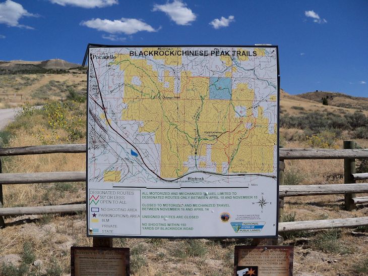
Trail Map at Entrance


That land-use message starts with how well the entrance or staging area facilities are maintained and continues with how the trails are signed.   Recreationists also look for how decommissioned or closed routes are identified and protected. 

TMR Prescriptions


Does the agency identify or sign restoration projects or special management designations such as “No Shooting Safety Zones” or “Wildfire/Wildlife Areas”?

Shooting Safety Zone


Are the camping areas and bathrooms clean?  Are the kiosks and information posters in good condition? 

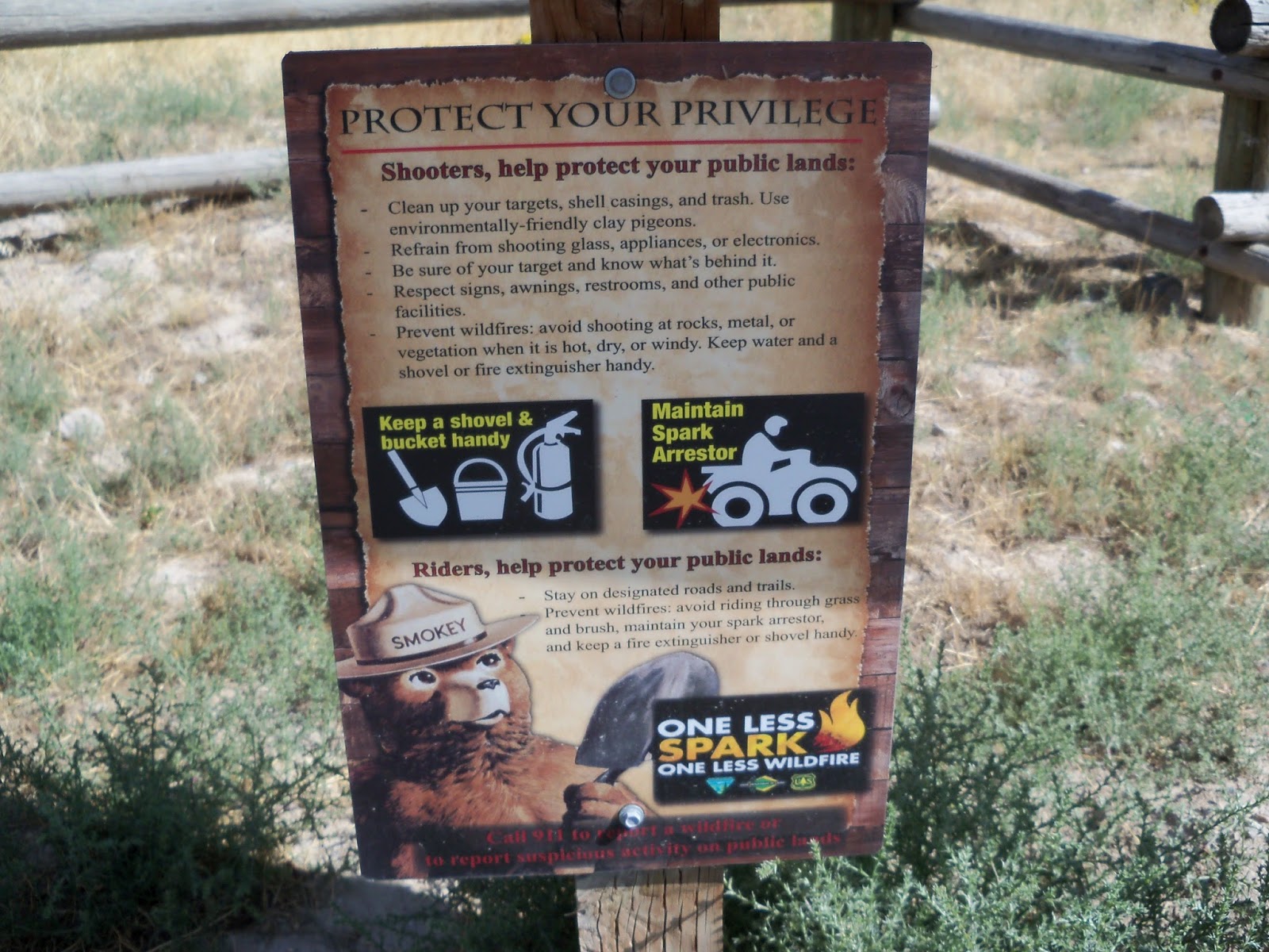
Info on Preventing Wildfires

Is there evidence of trail maintenance such as installed water control structures (i.e. rolling dips, lead off trenches, sediment catch basins, etc.)?

While on a recent trip to Idaho, QWR had the opportunity to ride/tour the Blackrock/Chinese Peak Trail System managed by the BLM’s Pocatello Field Office.   This recreation area sits on the outskirts of Pocatello, Idaho.

View of Pocatello from Ridge Trail


QWR believes this unit is a good example of how to manage motorized and non-motorized recreation in a wildland/urban interface.  The BLM starts by welcoming users to the area via a well-kept staging area that contains important user information such as seasons of use, types of allowed trail activities, map of the trail system, and fire prevention recommendations.

Management of Closed Routes


The roads and trails are well signed.  Closed routes and illegal shortcuts are clearly marked and signed.

Well Signed OHV Route

  
Illegal dumping can be an issue on a public unit, but this area has addressed that via appropriate signing and installation of vehicle barriers.

No Dumping Sign and Barricades


The Blackrock Canyon restroom was clean.  The kiosk and information posters were in excellent condition and contained relevant information.

Clean SST and Well Maintained Kiosk


The 50-inch trails for motorcycles, MTBs, and ATVS were clearly identified.  Trails for larger vehicles were also well signed and maintained.

50 inch Trail 


To some extent, management challenges will always exist regardless of where the unit is.  However, QWR believes that the level of public cooperation and respect for the land is directly proportional to the agency’s visual and on-the-ground commitment to managing the resource for current and future generations.  


Monday, August 24, 2015

Tesla Fire Spares Carnegie SVRA Core Riding Area

Carnegie SVRA Currently Closed to OHV

QWR just got back from a quick recon of the Tesla Fire which burned about 2,700 acres in eastern Alameda County.  The fire started on August 19, 2015 and appears to have spread eastward onto the currently closed expansion property at Carnegie SVRA.  On August 22, CALFIRE stated the fire was 100% contained.

Carnegie SVRA Core Riding Area Spared


Viewing the landscape from the Tesla/Corral Hollow Road today, it appears that most of the trails and supporting infrastructure, including the Park’s Sector Office, at the 1,500 acre riding area was spared from the wildfire.

Looking West Past SVRA Work Yard to Alameda Hills

QWR believes that wildfires in Oak grasslands are an important part of the environmental equation.  Grassland fires can help with the control of insects and disease.  Oak trees in general are fire resistant and we believe a lot of them will return next year in a stronger state of health.

Looking East from SVRA Sector Office 

 QWR also believes that fire can often be a benefit on landscapes where trail design and layout is planned.   With the vegetative cover removed, it is easier to see the lay of the terrain and how a proposed route can be constructed to take advantage of natural features to reduce water runoff and soil erosion.

Entrance to Tesla Mine 

QWR urges riders to monitor the Carnegie SVRA website for updates on when the park will reopen.  There may also be post-fire rehabilitation efforts that need the help from trail volunteers.  Let’s be supportive of SVRA staff as they work to reopen the park as soon as possible.

Carnegie SVRA Website

With wildfires burning throughout the West, QWR wants us all to remember the fire crews out on the frontlines working tirelessly to protect life, property, and natural/cultural resources.


Thursday, August 20, 2015

Archeological Site Stewardship Training is Valuable Trail Tool


The evolution of a well-trained and multi-disciplined volunteer OHV trail workforce is both impressive and important.  In the 21st Century, it has become a critical tool and force-multiplier for land management agencies to utilize in taking care of recreation facilities.

In many areas, highways, roads, and OHV/OSV trails overlay historic routes used by Native Americans and early pioneers to travel cross-country or for trading goods and services.  Because of their history, these trails and nearby areas have significant archeological value.

Kyburz Petroglyph Open to the Public

  
Three good examples of historic pioneer routes are the world famous Rubicon Trail, the Mormon Emigrant Trail, and the Henness Pass (Kyburz) Trail.  Segments of said routes provide important OHV and/or OSV opportunities.


LINK TO HENNESS PASS/KYBURZ PETROGLYPH INFO/MAP

QWR believes that trail volunteers have an increasingly important role to play in assisting Forest Archeologists as stewards to monitor cultural sites.  Trail volunteers are equipped to travel long distances and can access remote archeological sites under supervision by the Forest Archeologist.

Recently, Don Amador took the California Archaeological Site Stewardship Program (CASSP) Volunteer Workshop held on the Eldorado National Forest.  QWR believes this training is important for engaged trail volunteers because it expands their ability to assist the agency in managing OHV recreation as it relates to protecting archeological resources.


The volunteer training is managed by CASSP.  It received a 2014/2015 grant from the California OHMVR Division because it is an innovative partnership program designed to assist federal land management agencies balance the statutory requirements to protect cultural resources with their responsibility to sustain long-term OHV opportunities on public lands.

Through services provided by CASSP volunteers, agencies have been able to maintain OHV opportunities that would have been restricted in order to protect cultural resources. CASSP training workshops and CASSP volunteers also help agencies to educate the public about environmental responsibility, safety, and respect for private property. CASSP has become a critical element in conserving significant historical and prehistoric cultural resources.

According to the grant application, CASSP workshops and volunteers enhance existing OHV opportunities in three ways: helping to keep trails open, improving the visitor experience by providing information about the prehistory and history, and increasing communication, education, and understanding among different groups.

Historically, the management response has often been to close trails or restrict OHV opportunities. By monitoring and protecting archaeological and historical resources, CASSP helps maintain a balance between protecting cultural sites and responsible OHV recreational use of trails and OHV areas. Also OHV site stewards serve as role models and inform other off-highway vehicle users to follow the designated trails, ride responsibly, and remember to ride safely. As a result, the cultural resources, agencies, and volunteers all benefit.

With intense wildfires burning out important trail areas on National Forests throughout California and the West, QWR believes that post-fire trail rehabilitation efforts lends import to the CASSP training since wildfires often burn vegetation or trail delineators that protect archeological and cultural sites. 
  
QWR looks forward to incorporating the CASSP training into its ongoing trail stewardship module.

Big thanks to all of you trail volunteers out there that are already doing a great job!  Also, helmets off to the CA OHMVR Division for funding this grant in partnership with Region 5, USDA Forest Service.

To find out more about the CASSP training go to:

# # #


Tuesday, August 18, 2015

REPORT - Mega Fires Gut FS Recreation (and other) Accounts


Only "We" Can Prevent Mega-Fires

QWR believes the August 4, 2015 report; The Rising Cost of Fire Operations: Effects on the Forest Service’s Non-Fire Work, gives OHV recreationists and other public land stakeholders an easy to understand explanation on how catastrophic mega-fires are burning through agency resources.

This report highlights how funds are diverted from important accounts that support road/trail maintenance, recreation facilities, restoration projects, forest planning efforts, and cultivation/utilization of partnerships as force multipliers.

LINK TO REPORT

On page 2, the report states that the depletion of non-fire programs to pay for the ever-increasing costs of fire has real implications, not only for the Forest Service’s restoration work that would help prevent catastrophic fires, but also for the protection of watersheds and cultural resources, upkeep of programs and infrastructure that support thousands of recreation jobs and billions of dollars of economic growth in rural communities, and support for the range of multiple uses, benefits and ecosystem services, as well as research, technical assistance, and other programs that deliver value to the American public.

Prescribed Fire is a Forest Management Tool


On pages 11/12, the report notes the decrease in funding resulting from increased fire costs has limited the agency’s ability to provide vital recreational opportunities on NFS lands, which jeopardizes the thousands of jobs that are part of a growing recreational economy.

Logging is a Forest Management Tool

The agency has been unable to more fully implement sustainable Recreation, Heritage, and Volunteer Services and Wilderness and Wild & Scenic Rivers programs to provide consistent, quality recreation opportunities to the public. Reductions in recreation funding have a direct impact on local economies
supported by these activities, including many small outfitter and guide businesses that depend on
recreation sites and programs on NFS lands. Additionally, the Forest Service’s ability to leverage funds and implement projects with partners and volunteers is constrained by the reductions in funding and staff, substantially affecting services.

A Shaded Fuel Break is a Forest Management Tool


The report concludes that Congress must address the way the agency pays for fighting wildfires by supporting legislation that treats mega-fires as natural disasters such as tornadoes or hurricanes.

QWR believes that approach is worthy of consideration, but falls short in addressing the underlying cause of these mega-fires and that is the agency’s inability to engage in substantive, robust, and multi-dimensional forest health projects.  The solution may be a combination of both concepts?

QWR welcomes comments, criticisms, or observations.  Use the comment box so others can benefit from your comments or send them directly to: damador@quietwarriorracing.com


Tuesday, August 11, 2015

Forest Supervisor Notes Import of Wildfire Impacted Roads and Trails

Dual-Sport/Adventure/SUV Route to the
Lassics Botanical Area on the Six Rivers NF
(Area Closed Due to the Lassic Fire which is part of the Mad River Fire Complex)

Both street-legal and non-street legal OHV recreation is impacted by wildfires.  Many of the lightning-sparked fires burning in California and elsewhere in the West have understandably resulted in the immediate closure of popular routes used by dirt-bikes, ATVs, dual-sports, SxSs, 4WDs, SUVs, and adventure bikes.

In the long-term, what is most important for recreationists is the closure period of the Forest Order related to a fire event.  Some Forests institute a mandatory one-year or longer closure order to all public entry.  On the other hand, some Forest Orders state the closure is in effect until… “the fire is declared out” or the “fire season has ended.” 

QWR commends the Six Rivers National Forest Supervisor, Merv George Jr., for his commitment to reopening roads and trails once safe conditions are restored.

LINK TO SIX RIVERS NF PM FIRE UPDATE AND GEORGE STATEMENT ON ROADS/TRAILS

“We recognize the impact these roads, trails and area closures have on the public and these decisions have not been made lightly. These closures are necessary for public safety and fire operations,” said Merv George Jr., forest supervisor. “Knowing your desire to get into some of these areas as soon as possible, we will work with the incident management team and local law enforcement to lift the closures when it can be done safely.”

Once again, QWR urges riders to check in with your local Forest Service or BLM office to find out what roads, trails, and areas are closed due to wildfires.  A link with updated info is listed below:

LINK TO WILDFIRE INFO ON FS AND BLM LANDS

Stay safe!  Also, feel free to post comments on how things are going in your neck of the woods.

Knoxville OHV Staging Area

*QWR is concerned the Jerusalem Fire is headed for the BLM’s Knoxville OHV Area
LINK TO MAP