Tuesday, June 28, 2022

OP-ED - POST DISASTER RESTORATION KEY TO SUSTAINABLE RECREATION


Post COVID Restoration Project (circa 6/22)
Walker Ridge - BLM Ukiah Field Office


              POST DISASTER RESTORATION KEY TO SUSTAINABLE RECREATION

Land management professionals in both the private and public sectors have noted the increased amount of diverse recreational activities that exploded during and since the COVID pandemic.  It’s understandable that people wanted to escape the shutdowns by visiting the great outdoors that exist on public lands.


Off-Route Travel - Walker Ridge (circa 1/21)

Restoration of Off-Route Travel - Walker Ridge (circa 6/22)


Unfortunately, that increased use occurred when government offices were boarded up and field staff were directed to work from home with little, if any, in-person contact with the public.  It was almost impossible for recreation staff and seasonal workers to keep up with even the baseline services at campgrounds such as cleaning restrooms or picking up trash. 


The more specialized services such as trail maintenance and repairs also suffered from capacity challenges at local, state, and federal recreation areas.  With many designated campgrounds being overcrowded on the weekends, some users selected to “create” or “designate” their own defacto developed site that often included an informal trail network or play area where target shooting, fireworks, all night music parties, and other activities occurred that were not authorized or permitted on public lands.


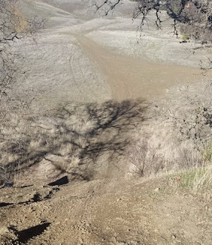
Off-Route Hill Climb - Walker Ridge (circa 1/21)

Restoration Off-Route Hill Climb - Walker Ridge (circa 6/22)


One of the issues that I noted at or near designated or historic OHV recreation areas were impacts to grasslands and forest regions from off-route travel where motorized use had not been authorized or allowed.


The good news is that numerous land agencies responded to unauthorized OHV and other recreational uses - and the resulting resource impacts - by completing significant restoration projects to regrow damaged vegetation, protect cultural resources, install or reconstruct soil loss mitigation structures, and replace damaged barriers and signage.

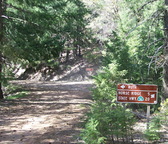
Information on Protecting Cultural Resources - Walker Ridge (circa 6/22)


One such unit is the BLM’s Ukiah Field Office that manages the Walker Ridge area.  There was an historic staging site that was impacted by illegal recreational activities where some groups unofficially created their own designated play area and route network that damaged lands not open for motorized use.


On a recent field trip to review post-COVID inspired recreation impacts to closed areas, I was pleased to see the BLM’s restoration efforts on Walker Ridge were successful in controlling soil loss, reestablishing native vegetation, enhancing vehicle barriers to restrict off-route travel, and signing to inform the public about protecting cultural/natural resources and what areas are open or closed to vehicle use.


Public lands will continue to face natural disasters of various types and the challenges they create for generations to come.  Having access to the appropriate tools and the ability to implement their use in a timely manner will ensure the future of sustainable recreation for outdoor enthusiasts.

# # # 


Monday, June 13, 2022

GOT IT DONE - BLM REPAIRS FIRE DAMAGED BRIDGES

OHV Bridge Post-Fire Repair
Photo courtesy of BLM


                 GOT IT DONE – BLM REPAIRS FIRE DAMAGED OHV BRIDGES


OHV bridges have become a critically important part of today’s sustainable trail systems on public land particularly in mountainous or forested regions.  Often they are used to relocate motorized use out of sensitive riparian areas to protect wildlife and water quality or to provide connectivity throughout a unit’s route network.

When those structures are damaged or destroyed by wildfires or other natural disasters, public access to designated roads and trails can be severely impacted for both casual use and permitted competition events. One such federal unit is the BLM’s South Cow Mountain OHV Recreation Area near Ukiah, California.


                             OHV Bridge - Before Repair                     OHV Bridge - After Repair
                                                           Photos courtesy of the BLM

It is a Congressionally-designated OHV recreation area where managed multiple-use OHV recreation is a prescribed use.  This almost 25K area facility has an extensive route network that provides various degrees of challenge for dirt-bikes, ATVs, SxSs, buggies, and 4WD vehicles.  It also provides motorized access to non-motorized activities such as mountain biking, wildlife views, and hunting.


          OHV Bridge - Before Repair                                   OHV Bridge - After Repair
                                                       Photos courtesy of BLM


In 2018, much of South Cow Mountain was devastated in the River Fire. Some of that destruction included a number of key OHV bridges that provided important connectivity within the route network.   Impacts to the bridge system created safety concerns and often resulted in trail closures or restrictions and also made it difficult for the agency to issue permits for historic off-road motorcycle events.

        Panther Creek OHV Bridge - Before Repair        Panther Creek OHV Bridge - After Repair
                                                     Photos courtesy of BLM

 QWR commends leadership and staff at the BLM Ukiah Field Office for their “git er done” attitude – during difficult times - to repair severely damaged OHV bridges and restore functionality and connectivity within the 94 mile network of designated roads and trails.  


                                                                              # # #

Sunday, June 5, 2022

POST FIRE OBSERVATION - FACE CHALLENGES AND EXTEND GRACE


CA BCDT - Post August Complex Fire Recon
Shasta-Trinity National Forest

Over the last several weeks, I had the opportunity to do my first large scale recon of areas that were impacted by the August Complex Fire.  As some of you know, on August 17, 2020 a severe lightning storm started 38 separate wildfires that eventually grew into what became known as the August Complex Fire. 

It was California’s first “Giga Fire” because it consumed over 1 million acres of private and public lands in or near the Mendocino, Shasta-Trinity, and Six Rivers National Forests.

Crest of FH7 - Pre August Complex Fire (circa 2015) 

    
Crest of FH7 - Post August Complex Fire (circa 2022)
                                                           

For many of us who worked or recreated on lands within the burn footprint it was a devastating and life changing event.  Many important natural and cultural resources along with high value recreation assets were consumed by the firestorm and altered for generations to come.  

Entering August Complex Fire Burn Footprint off of Highway 36
Shasta-Trinity National Forest

As somebody who has done a lot of post-fire recovery volunteer work on forest lands over the last 20 years, I want to state my appreciation to fire and recreation staff who worked hard to mitigate hazard trees, replace damaged signs, and address other management issues in high-use areas such as campgrounds and along key routes.


  Intersection - Pre August Complex Fire (circa 2010)


                                                                           Intersection - Post August Complex Fire (circa 2022)


On the other hand, there are many areas in the burn footprint that basically appear as they did after the fire was extinguished almost two years ago.  Many signs are burned up completely or wording is not legible. Road or trail barriers have been destroyed and remain as they were when the fire crews left.

Part of Forest Spared from August Complex Fire
Shasta-Trinity National Forest - (circa 2022)


Unfortunately, the large number of recent mega-fires compounded by ongoing COVID mitigation measures, retirements, and high cost of living in certain regions continue to create capacity challenges as the agency works to address routine management efforts, fuel reduction projects, and their recreation program.

Pre August Complex Fire - Valley View LO
Mendocino National Forest - (circa 2017)

Post August Complex Fire - Valley View LO
Mendocino National Forest - (circa 2022)

While trail volunteer crews can and do make a difference, the lack of agency volunteer coordinators combined with the high cost of living and astronomical fuel prices - that volunteers must address - does make that partnership model less sustainable at least for the foreseeable future.

Looking South towards Snow Mountain Wilderness from FH7
Mendocino National Forest - (circa 2022)


Despite the many challenges and obstacles confronting us, we need to take time to appreciate what we still have and that is access to much of our backcountry road and trail network.  Sure, some of the views are not as “scenic” as they once were, but maybe we can envision what it will look like for the next generation.

Many of our favorite trails are still there and a blast to ride even though they are now lined with the charred remains of fir or pine trees.

Loss of Forest Canopy over Cold Creek - Post August Complex Fire
Mendocino National Forest - (circa 2022)

And, when we plan a volunteer project it needs to respect and maximize the time donated by our volunteer work force to help the agency continue to provide a high quality recreation experience.

# # #