Tuesday, May 30, 2017

Adventure to Backcountry Treasure Kicks-Off Great Outdoors Month

Level 2 FS Road - Off of M2

Adventure and Dual Sport motorcycle enthusiasts often ask QWR if it has any suggestions on where to explore new (at least to many riders) remote federal land backcountry areas  with forests, scenic views, access to challenging motorized routes, and high elevation camping opportunities.

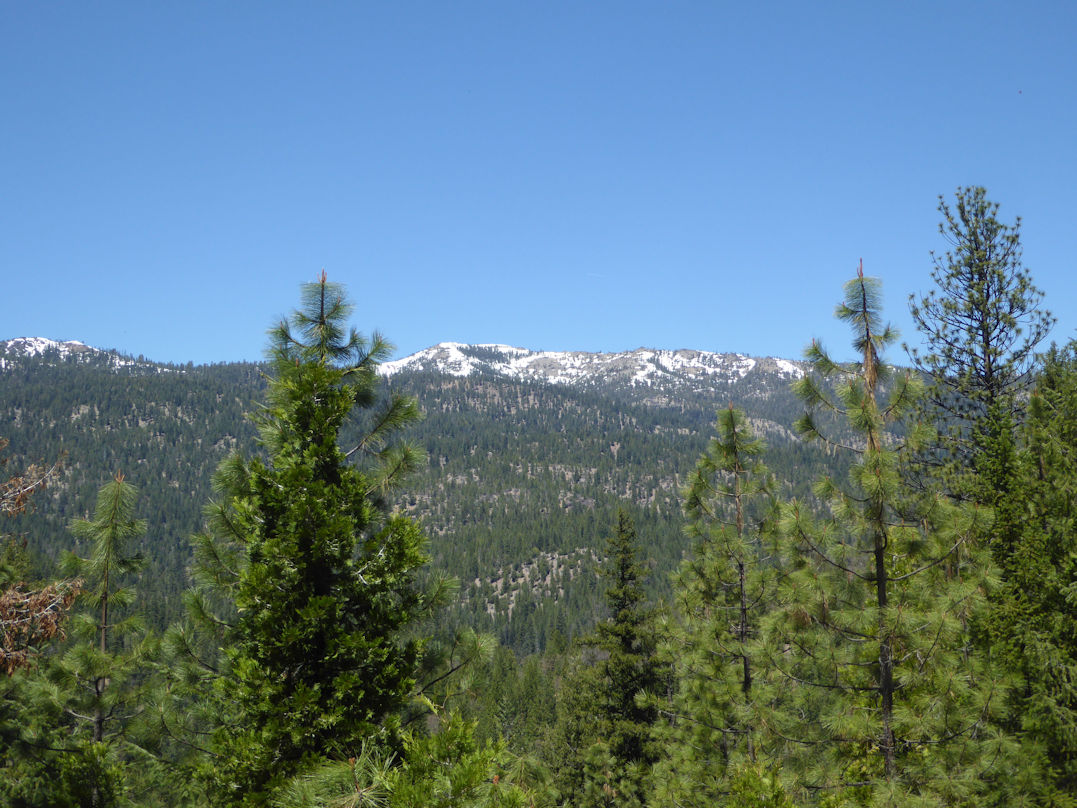
Ride Through Conifer Forest

While on a recent multi-day post-winter storm route assessment in the Northeast portion of the Mendocino National Forest, QWR was impressed to highlight and share an approximately 120-mile loop of high elevation native surfaced Forest Service System Roads (designated for street legal vehicles) that provide public access to both motorized and non-motorized backcountry recreational opportunities including the Yolla Bolly Middle Eel Wilderness area.

Map of Adventure Loop

QWR staged from the Stonyford Rodeo Grounds which hosts the annual Oakland Motorcycle Club’s SheetIron Dual Sport Ride.  QWR works with club members to staff the event’s tech inspection where vehicles are checked for sound compliant mufflers spark arrestors, and current registration.

Start of Adventure Loop

For the purposes of this article, the trip starts at Stonyford and continues north on County Road 306 for about 25 miles where the 1st leg of the 120-mile loop begins at the CR 313/306 intersection.  This too is where M9 starts.

Designated OHV Trail in Doe Peak Area

The road quickly gains altitude through a chaparral landscape to the ridge near Doe Peak (elev. 3557 ft.). The Doe Peak area has a number of designated OHV routes that offer varying degrees of difficulty for both street legal and non-street legal OHVs.

Looking West from Valley View Fire Lookout

QWR suggests that you travel a few more miles up M9 and watch for the Valley View Lookout sign which directs you a short distance to the site of the historic Valley View Fire Lookout.  Although the lookout is no longer there, the site gives you a breathtaking view across a “big forested valley.”  You will want to spend some time here taking in the scenery.

Log Springs Station

If you are trying to do this loop in one day, you will want to continue on to the Log Springs Summer Fire Camp.  This is a historic Forest Service fire station where you can stop and enjoy the big trees and shade.

Nome Cult Trail

Also at Log Springs is where the Nome Cult Indian trail crosses the route.  300 Indians from Chico and other northern California Tribes camped at this site in 1863 on their journey to Round Valley.  (see above pic for more info).   It is important to spend time here in contemplation of that event. 

Sugar Springs Campground

Just a short distance to the north of Logs Springs, you will enter the M9/M4 intersection where you will take a left and travel west through a conifer forest.  In about 5-7 miles you will want to take a lunch break at the Sugar Springs Campground.  This high-elevation site is in a stand of large trees.  It has a developed campsite with picnic table and fire ring.  There is also a vault toilet.

Depending on how many side routes you decided to explore, you may want to consider spending the night at this high elevation campground.  I know I plan to come back up here later this summer.

After leaving Sugar Springs Campground, you will travel a few miles to the M4/M2 intersection.  Take M2 north where it skirts the Yolla Bolly Middle Eel Wilderness area.  There are also many dispersed camping opportunities with scenic views of the Yolla Bolly Mountains including Sugar Loaf Mountain (elev. 7367 ft.).

View of Yolla Bolly Middle Eel Wilderness Area

On your 60 mile path east towards Paskenta, the road takes you past many dirt roads that are also open for non-street legal OHVs.   Watch for signs to Cold Springs, Post Pile, Kingsley Glade, and many other interesting sites.

Intersection in Paskenta

There is a small market in Paskenta that sometimes sells fuel.  It would be wise to check with them if you think a gas fill-up is in order.

M4/M9 Connector Intersection

From Paskenta, head southeast about 6 miles on Round Valley Road to the M4 intersection.  Head west on M4 a few miles until you reach the M4/M9 connector route intersection.  Take a left at the intersection and go a short distance to 23N05.  Stay left on 23N05 for about 6 miles until it intersects with M9.  Turn left on M9 and head back down the mountain to CR306 where this journey started.

Forest Management Project along M4

As we alluded to in the first part of this article, this is a very remote and rugged portion of California.  There are basically no services.  Riders have to be well prepared to take on bike repairs, etc.  A good first aid kit is recommended and also a satellite locator that can be used in an emergency.

Enjoy the Ride

QWR was unable to do about a 25 mile section in the NW part of this loop due to a large downed tree across M2 (it was reported to the FS).  Be sure and contact the Mendocino National Forest to see if the roads are clear. 

LINK to North FS MVUM Map (mostly M4/M2)

LINK to North Central FS MVUM Map (mostly M9)


June is Great Outdoors Month and QWR’s adventure bike module hopes some of you might decide to challenge yourself on this loop.  If you go, please let us know how you liked this remote portion of the Forest.  It will be an adventure to be remembered. 

# # # 

PS – This would also be a great adventure loop for those of you with high clearance SUVs and 4WDs.


Tuesday, May 23, 2017

Kawasaki KLR 650 Camo “Trail Recon” ADV Bike Project Report

QWR's 2017 Kawasaki KLR 650 Camo "Trail Recon" Project Build

QWR believes the 2017 SheetIron Dual Sport Ride was the perfect venue from which to announce a long overdue vehicle upgrade to our “Adventure Bike” module.  

Hosted by the Oakland Motorcycle Club, the annual event stages from the Stonyford Rodeo Grounds where approximately 500 dual sport and adventure bike enthusiasts travel on public land routes and county/state paved/non-paved roads from the eastern border of the Mendocino National Forest through BLM’s Cow Mountain OHV Area to the coastal town of Fort Bragg, California.

QWR selected Kawasaki’s KLR Camo 650 for our “Trail Recon” Adventure bike project.  The goal was to build a trail-worthy and dependable bike capable of both single and multi-day long range trail recon trips on Forest Service and BLM lands to inventory and/or assess current road/trail conditions and to analyze routes for future designation recommendations to enhance high quality backcountry access for adventure motorcyclists.

TUSK ADV/DS Crash Guards

The first order of the day was to contact our friends at Rocky Mountain ATV/MC for a set of their popular TUSK Dual Sport/ADV Crash/Engine Guards to protect the bike should it have any unplanned meeting with trail obstacles.  Installation was straight forward.


TUSK Aluminum Panniers w Pannier Racks

 Next on the list was a set of their TUSK Aluminum Panniers with Pannier Racks.  They were ordered in size Medium so as to keep a slimmer profile while still being able to hold tools, tire tubes, first aid kit, BIG BOY Silky Folding Saw, modest camping supplies, and other necessities. 

SW-Motech Centerstand
   
The folks at Twisted Throttle signed on to help with some cool SW- Motech products to further improve the functionality of the bike with a center stand to aid with tire/tube repairs out in the boondocks.

SW-Motech Skid Plate

Next was installation of the SW-Motech aluminum skid plate/engine guard which helps protect the bike’s underbelly from unexpected impacts from sharp rocks or other hard obstacles.

SW-Motech DAYBAG 600

The SW-Motech Day Bag 600 was selected for those multi-day overnight trips where extra clothes and other gear are needed to improve any overnight stay in the backcountry.

IMS ADV 2 Footpegs and Shifter

Being a fan of IMS products, QWR wanted to add the IMS ADV 2 stainless steel footpegs which offer the rider a large platform upon which to stand.   They are very comfortable and help instill a sense of security.  The IMS shifter enhanced the rider’s shifting ability with adventure boots on.


QWR has chosen to evaluate the bike with the current factory suspension that was recently upgraded.  Having done 450 miles over the last few days on paved and native surfaced roads might have proved to be a wise choice.

Seat Concepts KLR 650 Seat

Over the years, QWR has become a big fan of Seat Concepts and the giant strides they have made in off-road and adventure seat comfort.   Getting one of Seat Concepts' KLR seats was a must have and was put to good use during this recent trail recon ride.

MRA-Vario Touring Windscreen

Another product to help complete the initial build was a MRA-Vario Touring Windscreen from Twisted Throttle.  It deflects the wind stream at highway speeds to just above the visor on my KLIM F4 helmet while allowing an unobstructed view of the trail.

Kawasaki KLR 650 Tank Bag

 Holding small items like cameras, maps, air gauge, power bar, cell phone, reading glasses, etc. was given to Kawasaki’s TRANS TANK BAG.  The padded tank bag has numerous zipped pockets or sections where you can stow items neatly away.  It has a very custom fit and blends in well with the overall “Camo” or Team Stealth concept of the bike build.

Emgo Rear Trunk

Lastly, QWR wanted a small locking trunk so we selected the Emgo Travel Trunk that holds additional small to medium sized items.

QWR believes that riding 450 miles over the last few days on county paved and/or gravel roads and Forest Service dirt roads and trails in elevations from 1,500 ft. to 6,000 ft.  was a good initial test for our Trail Recon Project Build.  The Kawasaki Camo KLR 650 performed flawlessly and got 50 mpg which gives it a range of about 250 miles or so.

Trail Recon ADV Bike on Mendocino NF

All of the products worked in harmony to help create our official Trail Recon Adventure Bike that has been dedicated to help ADV and DS riders enjoy continued access to high-quality backcountry recreational experiences for current and future generations.

FS OHV Route - Mendocino NF


QWR wants to thank our following partners and sponsors;  Kawasaki Motor Corps., U.S.A, Roseville Kawasaki, Rocky Mountain ATV/MC, Twisted Throttle, IMS, and Seat Concepts for their generous support of this project and our efforts to promote and protect responsible motorized recreation on public lands.


Tuesday, May 16, 2017

Collaboration/Engagement/Commitment Reflected in CA DOT OHV Fuel Tax Report

State Park Director, Lisa Mangat, Speaks to OHVers
2015 OHMVR Commission Field Trip/NOHVCC Workshop
Prairie City SVRA, CA

QWR believes successful OHV programs are the result of substantive collaboration between agency leadership and the user community.

QWR wants to commend the California Department of Parks and Recreation (DPR) for engaging with the OHV community at various OHMVR Commission meetings in Northern and Southern California over the last couple of years.

That engagement also included a number of OHV-related Parks Transformation Team hearings where DPR Director, Lisa Mangat, and OHV commissioners gathered input on just how important the CA OHV Program is to millions of recreationists, federal partners, county law enforcement, rural economies, and conservation efforts.

2016 DPR/OHV Commission Public Hearing on Transformation Process
Ontario, CA


LINK TO CA DOT FUEL TAX REPORT WITH COVER LETTER

QWR believes that two-way collaboration is acknowledged by the administration’s strong support for continued funding for the CA OHV Program as stated in the Cover Letter for the CA Department of Transportation’s Report: “Assessing the State Fuel Tax Paid on Gasoline Used for Off-Highway Vehicle (OHV) Recreation.”

QWR also believes the Administration supports full funding for the CA OHV program in both SB 1 and the Governor’s Budget May Revise.

Thanks to all who have taken the time to engage with decision-makers.    

Tuesday, May 9, 2017

The Big View – Sustainable Shared-Use Trail Management

The Big View Trail (Trail 10) 
Rock Creek Trail System- Eldorado NF

Modern trail management is not just about OHV recreation.  It also applies to a wide variety of other outdoor trail-based activities which include mountain bikes, equestrians, and hikers.

Trail Management Sign for Shared-Use 


As outdoor trail-based recreation continues to grow in popularity throughout the country, QWR supports those public land agencies and private sector units that have embraced wet weather-based and other management prescriptions that help protect trail integrity and conserve natural resources.

Sediment Catch Basin/Rolling Dip - Shared-Use Trail

A recent review of the Mace Mill (Rock Creek) trail network, prompted QWR to highlight the ongoing effort by Eldorado National Forest recreation staff to manage and maintain mixed-use trail opportunities to sustain high-quality outdoor experiences for a diverse user community.

Shared-Use Trail

QWR believes there are three key components (3 Cs) to successfully managing a unit that offers mixed-use or shared-use trail-based opportunities for motorized and non-motorized recreation.  Those factors are commitment, communication, and collaboration.

FS Information Booth at 2017 Fools Gold Enduro


3C engagement between agency staff and user groups can occur in a number of ways.  Those venues or methods may include formal recreation advisory councils (RACs), substantive and updated websites/social media, joint field trips, volunteer projects, agency staff attending club meetings or events to provide current information, and/or just picking up the phone to ask a question or offer help.

Trail Courtesy Sign

QWR has an axiom that “The quality of your local trail recreation program is or will be directly proportional to the quality of your engagement with agency staff and other users.”

If you have not done so already, QWR urges both user groups and agency staff to make that long-term commitment to help ensure current and future access to high quality trail-based recreational opportunities.  


Tuesday, May 2, 2017

Need for Trail Volunteer Workforce Continues to Grow

Clearing 50-inch OHV Trail
Mendocino NF

Between April 27-30, 2017, up to 4 trail clearing crews comprised of certified volunteer chainsaw operators,  other volunteers, and Forest Service recreation staff worked together to clear recreation trails and roads impacted by downed trees and/or overgrown vegetation. 

Private Sector/FS Trail Clearing Crew

The coordinated effort took place at the Stonyford OHV Area on the Grindstone Ranger District which is located on the Mendocino National Forest in Northern California.  This is part of the ongoing volunteer trail program managed by agency staff in cooperation with private sector recreation stakeholders.

Trying out the Kobalt 80 Volt Electric 14-Inch Chainsaw

 According to the agency, the south end of the Grindstone Ranger District offers over 200 miles of some of the most enjoyable and challenging OHV routes in the nation. The "Mendocino OHV Corridor" is a designated 40 mile, east-west route across the south end of the Forest connecting the Stonyford OHV Staging Area and the Upper Lake OHV Staging Area.

Before Brushing on Trail 20

The riding area varies in elevation from 1,700 feet (at Fouts Springs), to almost 6,000 feet (near Goat Mountain). Vegetation varies from low elevation chaparral to tall pine and fir forest in the high country.

After Brushing on Trail 20

The Grindstone Ranger District not only offers access to high quality OHV recreation, but its extensive route network provides motorized access to non-motorized activities such as equestrian use and hiking in various Wilderness areas, fishing in streams and lakes, and dispersed camping in the backcountry.

Clearing Log on Forest Road M10 for Motorized Access
to Non-Motorized Recreation

The Forest Service states it established a policy for training and use of cross-cut and chain saws. Sawyers covered by those policies often maintain trails on national forests and grasslands, help fight wildfires, and work in wilderness where crosscut saws are required. The national saw directive standardizes training, evaluation, certification, and safety procedures for sawyers operating on lands managed by the agency.

LINK TO FS NATIONAL SAW POLICY

Volunteers taking the chainsaw course need to become Red Cross certified in First Aid, CPR, and AED.  It is a requirement for chainsaw certification. QWR encourages trainees to take the course well ahead of the chainsaw class.

Monitoring Soil Catch Basins/Trail Conditions 
Example of Functioning Sediment Catch Basin and Rolling Dip

Managing sustainable OHV and other recreation programs on federal lands is a complex challenge in the 21st Century.  QWR believes the need for a trained professional volunteer workforce will continue to grow as federal agencies roll out new programs such as the Forest Service’s National Trail Strategy or face fiscal impacts such as budget cutbacks.

A Motorcycle-Based Chainsaw/Swamp Team
Steve Freitas/Valley Climbers MC (L) and Don Amador (R)

QWR wants to thank the Mendocino National Forest, Oakland Motorcycle Club, Polka Dots Motorcycle Club, Valley Climbers Motorcycle Club, and the other work party volunteers for their commitment to helping maintain access to high quality motorized and non-motorized recreation on public lands.