Tuesday, November 15, 2022

SEE the FUTURE OF ROV/SXS RECREATION


ROHVA Basic DriverCourse - BLM Chappie Shasta OHV Area
BLM Redding Field Office


SEE the FUTURE OF ROV/SXS RECREATION


QWR is proud to announce that it is now offering the Recreational Off-Highway Vehicle Association (ROHVA) ROV Basic DriverCourse (RBDC) to agency, corporate, and private sectors in the Greater Redding Area in Northern California.


To kick-off our ROV training program in the North State, QWR taught the RBDC yesterday at the BLM’s Chappie Shasta OHV Area that has a long history of supporting OHV educational opportunities.


Exercise 4 - Backing and Turning

Search, Evaluate, and Execute (SEE) is one of the many important themes stressed by ROHVA in both the online E-Course and field training.   SEE is a common sense yet powerful decision-making process where a driver looks for various factors such as trail difficulty then evaluates the risk level of the situation and subsequently executes an action such as turning around and taking another route.


Protective safety gear is also another area that is highlighted during online and field education process.  Wearing a helmet, using eye protection, gloves, long sleeved shirt/jersey, and over-the-ankle-boots with non-slip soles can help the driver have a safe and fun trail experience.


As a ROHVA-certified DriverCoach, QWR’s Don Amador, states, “It was great to get back out in the field yesterday at the BLM’s Chappie Shasta OHV Recreation Area helping train outdoor recreationists about how to safely operate a ROV/SxS on designated road, trails, and areas.”   

Exercise 5 - Serpentine Forward and Reverse 


“I always enjoy seeing students taking pride in learning some of the basic skills such as two-feet throttle/brake control [Exercise 4]to cross an obstacle, back-up, or load the SxS into a tight area such as toy hauler.  At the post field training wrap up stated they could SEE just how important it is for drivers to get the proper training so they recreate in a safe and responsible manner,” Amador concludes.  

QWR's Don Amador - Preparing to an Exercise


 Also since many federal/state agencies and cooperators have increased the use of ROVs for recreation/resource management and fire suppression activities, QWR offers the RBDC course for agency or cooperator staff that need to get certified or recertified before operating a government or corporate SxS/ROV.


QWR is a strong supporter of the focused safety efforts by our partners at CA State Parks OHMVR Division, Forest Service, Bureau of Land Management, ROHVA, Tread Lightly!, and the CA Outdoor Recreation Foundation to address the rapid growth of ROV/UTV/SxS use on public lands.

# # # 

Sunday, November 6, 2022

QWR PSA - DON’T HIT THAT DEER

Deer Whistle installed on Kawasaki KLR 650


QWR PSA - DON’T HIT THAT DEER

 Growing up in the Pacific Northwest, one learns at an early age to WATCH OUT for deer crossing the roads between dusk and dawn since they often decide to cross a road at the same time you are driving.  One also learns that it’s not the deer you see that gets you but the deer or two following them across your path.

Almost all of us have either hit or had a near miss with a deer or know a family member or friend who has hit or missed a deer.  It’s not just cars and trucks that deer fixate on … they also seem to take on motorcycle riders too.

Deer Whistle installed on Ford F-250


A few months after moving up to Cottonwood near Redding, one of our relatives who is a long time resident of the area strongly suggested that we purchase some deer whistles to help reduce – but not eliminate – the chance of a collision with a deer.

So I took her advice and ordered a large set of deer whistles that had good reviews.  I ordered them from Amazon Prime and after they arrived, I installed them on all of my street legal cars, trucks, and motorcycles.

After I received my set of CITKOU 8Pcs Deer Whistles, I installed them on my vehicles and have been using them for about 8 months.  While some drivers may scoff at their effectiveness, I did notice that the deer I saw along the road did, in fact, react to the sound being emitted from the whistle.

Regardless of what brand you get, they are pretty inexpensive so what is the harm if they only work part of the time?  The only down side to getting what I think is pretty cheap deer collision insurance is they only work above 35 mph or so.

Now that the time has changed and we have more dark hours to drive in, it may be worth your while to purchase a set of deer whistles and install them on your vehicles.  

# # #  

Wednesday, October 26, 2022

SHOW ME THE SIGN – SxS SAFETY

FS Trail Marker with Vehicle Types Allowed - Mendocino NF


SHOW ME THE SIGN – SxS SAFETY


In August 2022, the CA State Parks OHMVR Division – in partnership with Tread Lightly! and the CA Outdoor Recreation Foundation -  hosted a safety summit at their McClellan Training Center in Sacramento.  For many it was their first in-person major conference in 2.5 years due to COVID restrictions.  It was attended by various key state and federal agency representatives, powersports industry leads, major OHV organizations, ROV/UTV trainers, motorized media outlets, law enforcement, competition event organizers, and educational non-profits.

FS Route Marker with Vehicle Types Allowed - Mendocino NF


The primary focus was on improving/updating safety efforts to address the rapid growth of ROV/UTV/SxS use on public lands.  The summit was successful since it planted the “safety standard” in the ground to mark this effort and to recognize the commitment by those in attendance to improve safety and reduce impacts to natural resources and other user groups.

August 2022 CA State Parks Safety Conference


What makes this SxS-related safety program important is that many owners of these vehicles have very little if any experience in motorized backcountry recreation on public lands.  Often they are not aware of the various land management agencies or their efforts to manage travel on legal routes.

End of Combined-Use County OHV Connector Route


Having just got back from doing a trail management survey at the Stonyford OHV Area on the Mendocino National Forest, I remain convinced one of the most important travel management tools is a quality trail signing program.


In my opinion, the most effective signing program uses a combination of positive and negative reinforcement strategies to inform the rider/driver on what routes are open or closed for their specific vehicle type.

OHV "50-inch" Trail for Motorcycles and ATVs - No SxSs Allowed


As this new safety initiative continues to build capacity to address SxS-related management needs, it is important for the greater OHV community to increase efforts to share our responsible use message and one good source comes from our friends at Tread Lightly!  and their RESPECTED ACCESS campaign.


https://treadlightly.org/campaigns/respected-access/


 Thanks for your interest in managed OHV recreation!


Thursday, October 20, 2022

ATTEND OHV Meetings in Nor Cal to Improve BLM OHV Opportunities


Our friends at the National Off-Highway Vehicle Conservation Council (NOHVCC)  are working in partnership with the CA Bureau of Land Management (BLM), to create a California Statewide OHV Action Plan. They are holding a series of meeting in northern CA in November and need your assistance in learning how the BLM can better provide access to high quality OHV recreation experiences in the state of California.


As a NOHVCC CA State Partner, QWR is encouraging riders to attend the first round of listening sessions: All sessions will be held from 6pm - 9pm


• November 14: Milpitas, CA: Holiday Inn Express & Suites Silicon Valley, 1100 Cadillac Ct, Milpitas, CA 95035,

• November 15: Ukiah, CA, Ukiah Valley Conference Center, 200 S School Street, Ukiah, CA 95482

• November 16: Eureka, CA, Red Lion Eureka, 1929 4th Street, Eureka, CA 95501

• November 17: Redding, CA, Win River Resort & Casino, 2100 Redding Rancheria Road, Redding, CA 96001

• November 18: Susanville, CA, The Historic Susanville Rail Depot, 601 Richmond Road, Susanville, CA 96130

• November 21, Sacramento, CA, Hilton Sacramento Arden West, 2200 Harvard Street, Sacramento, CA 95815


Here is a link for more information on these upcoming events.

https://nohvcc.org/event/northern-california-blm-listening-sessions-november-14-2022-milpitas-ca/

RSVP - https://nohvcc.org/engagement/attend-a-nohvcc-event/

Thanks for your review and please feel free to share with your OHV network.


Tuesday, June 28, 2022

OP-ED - POST DISASTER RESTORATION KEY TO SUSTAINABLE RECREATION


Post COVID Restoration Project (circa 6/22)
Walker Ridge - BLM Ukiah Field Office


              POST DISASTER RESTORATION KEY TO SUSTAINABLE RECREATION

Land management professionals in both the private and public sectors have noted the increased amount of diverse recreational activities that exploded during and since the COVID pandemic.  It’s understandable that people wanted to escape the shutdowns by visiting the great outdoors that exist on public lands.


Off-Route Travel - Walker Ridge (circa 1/21)

Restoration of Off-Route Travel - Walker Ridge (circa 6/22)


Unfortunately, that increased use occurred when government offices were boarded up and field staff were directed to work from home with little, if any, in-person contact with the public.  It was almost impossible for recreation staff and seasonal workers to keep up with even the baseline services at campgrounds such as cleaning restrooms or picking up trash. 


The more specialized services such as trail maintenance and repairs also suffered from capacity challenges at local, state, and federal recreation areas.  With many designated campgrounds being overcrowded on the weekends, some users selected to “create” or “designate” their own defacto developed site that often included an informal trail network or play area where target shooting, fireworks, all night music parties, and other activities occurred that were not authorized or permitted on public lands.


Off-Route Hill Climb - Walker Ridge (circa 1/21)

Restoration Off-Route Hill Climb - Walker Ridge (circa 6/22)


One of the issues that I noted at or near designated or historic OHV recreation areas were impacts to grasslands and forest regions from off-route travel where motorized use had not been authorized or allowed.


The good news is that numerous land agencies responded to unauthorized OHV and other recreational uses - and the resulting resource impacts - by completing significant restoration projects to regrow damaged vegetation, protect cultural resources, install or reconstruct soil loss mitigation structures, and replace damaged barriers and signage.

Information on Protecting Cultural Resources - Walker Ridge (circa 6/22)


One such unit is the BLM’s Ukiah Field Office that manages the Walker Ridge area.  There was an historic staging site that was impacted by illegal recreational activities where some groups unofficially created their own designated play area and route network that damaged lands not open for motorized use.


On a recent field trip to review post-COVID inspired recreation impacts to closed areas, I was pleased to see the BLM’s restoration efforts on Walker Ridge were successful in controlling soil loss, reestablishing native vegetation, enhancing vehicle barriers to restrict off-route travel, and signing to inform the public about protecting cultural/natural resources and what areas are open or closed to vehicle use.


Public lands will continue to face natural disasters of various types and the challenges they create for generations to come.  Having access to the appropriate tools and the ability to implement their use in a timely manner will ensure the future of sustainable recreation for outdoor enthusiasts.

# # # 
 

Monday, June 13, 2022

GOT IT DONE - BLM REPAIRS FIRE DAMAGED BRIDGES

OHV Bridge Post-Fire Repair
Photo courtesy of BLM


                 GOT IT DONE – BLM REPAIRS FIRE DAMAGED OHV BRIDGES


OHV bridges have become a critically important part of today’s sustainable trail systems on public land particularly in mountainous or forested regions.  Often they are used to relocate motorized use out of sensitive riparian areas to protect wildlife and water quality or to provide connectivity throughout a unit’s route network.

When those structures are damaged or destroyed by wildfires or other natural disasters, public access to designated roads and trails can be severely impacted for both casual use and permitted competition events. One such federal unit is the BLM’s South Cow Mountain OHV Recreation Area near Ukiah, California.


                             OHV Bridge - Before Repair                     OHV Bridge - After Repair
                                                           Photos courtesy of the BLM

It is a Congressionally-designated OHV recreation area where managed multiple-use OHV recreation is a prescribed use.  This almost 25K area facility has an extensive route network that provides various degrees of challenge for dirt-bikes, ATVs, SxSs, buggies, and 4WD vehicles.  It also provides motorized access to non-motorized activities such as mountain biking, wildlife views, and hunting.


          OHV Bridge - Before Repair                                   OHV Bridge - After Repair
                                                       Photos courtesy of BLM


In 2018, much of South Cow Mountain was devastated in the River Fire. Some of that destruction included a number of key OHV bridges that provided important connectivity within the route network.   Impacts to the bridge system created safety concerns and often resulted in trail closures or restrictions and also made it difficult for the agency to issue permits for historic off-road motorcycle events.

        Panther Creek OHV Bridge - Before Repair        Panther Creek OHV Bridge - After Repair
                                                     Photos courtesy of BLM

 QWR commends leadership and staff at the BLM Ukiah Field Office for their “git er done” attitude – during difficult times - to repair severely damaged OHV bridges and restore functionality and connectivity within the 94 mile network of designated roads and trails.  


                                                                              # # #

Sunday, June 5, 2022

POST FIRE OBSERVATION - FACE CHALLENGES AND EXTEND GRACE


CA BCDT - Post August Complex Fire Recon
Shasta-Trinity National Forest

Over the last several weeks, I had the opportunity to do my first large scale recon of areas that were impacted by the August Complex Fire.  As some of you know, on August 17, 2020 a severe lightning storm started 38 separate wildfires that eventually grew into what became known as the August Complex Fire. 

It was California’s first “Giga Fire” because it consumed over 1 million acres of private and public lands in or near the Mendocino, Shasta-Trinity, and Six Rivers National Forests.

Crest of FH7 - Pre August Complex Fire (circa 2015) 

    
Crest of FH7 - Post August Complex Fire (circa 2022)
                                                           

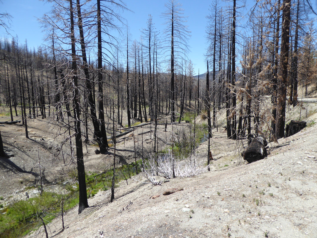
For many of us who worked or recreated on lands within the burn footprint it was a devastating and life changing event.  Many important natural and cultural resources along with high value recreation assets were consumed by the firestorm and altered for generations to come.  

Entering August Complex Fire Burn Footprint off of Highway 36
Shasta-Trinity National Forest

As somebody who has done a lot of post-fire recovery volunteer work on forest lands over the last 20 years, I want to state my appreciation to fire and recreation staff who worked hard to mitigate hazard trees, replace damaged signs, and address other management issues in high-use areas such as campgrounds and along key routes.


  Intersection - Pre August Complex Fire (circa 2010)


                                                                           Intersection - Post August Complex Fire (circa 2022)


On the other hand, there are many areas in the burn footprint that basically appear as they did after the fire was extinguished almost two years ago.  Many signs are burned up completely or wording is not legible. Road or trail barriers have been destroyed and remain as they were when the fire crews left.

Part of Forest Spared from August Complex Fire
Shasta-Trinity National Forest - (circa 2022)


Unfortunately, the large number of recent mega-fires compounded by ongoing COVID mitigation measures, retirements, and high cost of living in certain regions continue to create capacity challenges as the agency works to address routine management efforts, fuel reduction projects, and their recreation program.

Pre August Complex Fire - Valley View LO
Mendocino National Forest - (circa 2017)

Post August Complex Fire - Valley View LO
Mendocino National Forest - (circa 2022)

While trail volunteer crews can and do make a difference, the lack of agency volunteer coordinators combined with the high cost of living and astronomical fuel prices - that volunteers must address - does make that partnership model less sustainable at least for the foreseeable future.

Looking South towards Snow Mountain Wilderness from FH7
Mendocino National Forest - (circa 2022)


Despite the many challenges and obstacles confronting us, we need to take time to appreciate what we still have and that is access to much of our backcountry road and trail network.  Sure, some of the views are not as “scenic” as they once were, but maybe we can envision what it will look like for the next generation.

Many of our favorite trails are still there and a blast to ride even though they are now lined with the charred remains of fir or pine trees.

Loss of Forest Canopy over Cold Creek - Post August Complex Fire
Mendocino National Forest - (circa 2022)

And, when we plan a volunteer project it needs to respect and maximize the time donated by our volunteer work force to help the agency continue to provide a high quality recreation experience.

# # #